Field-proven Survey and Mapping Software for any Android devices and ELNAV controllers
Designed for high precision surveying and mapping tasks, LandStar7 provides seamless workflow management, easy-to-learn and easy-to-use graphical user interface to complete all your projects efficiently. Comprehensive data import and export formats, multiple measurement and stakeout methods ensure instant productivity.
EASY WORKFLOW FROM FIELD TO OFFICE
Support various import and export format types
LandStar7 imports and exports DXF, SHP, KML, KMZ, CSV, DAT, TXT as well as fully customized data content from the survey project choosing CSV, DAT or TXT formats.
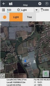
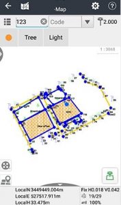
BACKGROUND BASEMAP OVERLAY
Locate and vizualise your project data at a glance
LandStar7 integrates Google, OSM, BING and WMS online maps to provide meaningful location information to surveyors and construction professionals. Projects are vizualized within their regional terrain or satellite images in real-time.
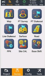
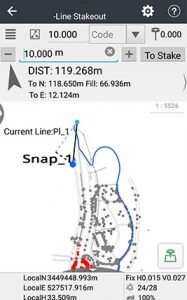
FEATURE RICH ANDROID SURVEY SOFTWARE
Highly versatile and ready for multiple applications
LandStar7 is designed to provide you with exceptional feature sets, from land surveying, construction and engineering projects, mapping, GIS data collection, road stakeout to pipeline survey. Its customizable user interface keeps LandStar7 easy-to-use by focusing on essential functions effectively commonly used.
DESIGN FOR SURVEYORS BY SURVEYORS
Agile software development process
Our LandStar7 development team keeps permanent contact with surveyors, construction professionals and our worldwide partners network to bring new outstanding fonctionalities. When using LandStar7 today, you are ensure to benefit from regular new features at no extra cost.